Grove Hall History
This article was first published by the Youth Violence Systems Project - Getting to the Roots (link). It has been reproduced here with permission.
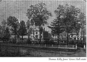 The name “Grove Hall” comes from the name of the mansion of the wealthy merchant, Thomas Kilby Jones, built about 1800 on a knoll overlooking the intersection of what is now Blue Hill Avenue and Washington Street. This area remained largely rural in character during the first half of the 1800s. However, after Roxbury was annexed to Boston in 1868, it developed more rapidly. From 1906 until the 1950s, Grove Hall and surrounding areas were important centers of Jewish life and religion. By the 1930s some African Americans had moved to upper Roxbury, and by 1950 the numbers had grown in the areas around St. Mark’s Congregational Church and Charles Street AME Church. The Grove Hall area experienced a major racial transition in the 1950s and 1960s with the Jewish population moving out to the suburbs. Those years and some of the following period were turbulent times. In the last 15 years the areas along Blue Hill Avenue and the heart of Grove Hall have seen considerable investment and renaissance with a new shopping center, renovations, and new buildings.
One of the early landholders in the area was Edward Payson who owned more than a thousand acres in the 1600s. He came to Roxbury in 1634 and moved to Dorchester near the Roxbury line in 1658.1 When he died in 1689, he left property to his sons and sons-in-law.2 His son Samuel received the western part of his lands near the Grove Hall area, including the homestead where he farmed all his life. He was a constable, selectman, and one of the leading citizens.3 This homestead or its site was then owned by John Goddard, and in 1747 he began operating a tavern there.4 Between 1754 and 1756, Stephen Kent moved from Chelsea to Roxbury, and in 1763 he received approval to operate the tavern at this site. “He hath lately hired a house in Roxbury which hath for many years been occupied as a tavern and was not long since improved as such by one Goddard.”5 Stephen died in 1767, and his wife took over as innkeeper for about the next 30 years.6 In 1796 it ceased operations as a public house. Not many years after that, Grove Hall was built on this site (what is now the South East corner of Blue Hill Avenue and Washington Street).
 In the 1700s, Governor Increase Sumner (Jr.) also owned land in the Grove Hall area.7 The governor’s grandfather, Edward Sumner, owned several lots in Roxbury and Dorchester, and his father, Increase (Sr.) was an industrious farmer with legendary strength who developed what was called the Morgan Farm. When his father died in 1774, Increase, Jr. inherited the farmland, although he made his home on what is now Bartlett Street in town. He was for many years a judge on the Massachusetts Supreme Court before becoming governor in 1797. He was also a talented farmer and taught his son the art of grafting fruit trees. His son, General William Hyslop Sumner, who
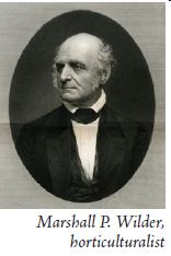
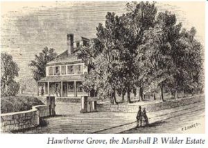
inherited the estate in 1799, was a founder of the Massachusetts Horticultual Society and the developer of East Boston. In 1832 Marshall P. Wilder purchased the Sumner estate, and for the next half century used the land to experiment with many varieties of fruit trees, plants and flowers. The property included most of the land between Washington Street, Columbia Road and Normandy Street. At one time his pear orchard included 2,500 trees of 800 varieties.8 He introduced several new pears including the Anjou pear. He also grew America’s finest collection of Camelias (300 varieties) and was the first in the US to grow and display a number of other flowers like orchids and Japanese lilies.9 In his own way, Mr. Wilder sought to bring beauty to Grove Hall. In general, Grove Hall in the first half of the nineteenth century was sparsely settled and mostly characterized by country estates, farms, and orchards.
Roads, street railways, and railroads have influenced the development of the Grove Hall neighborhood over the years. In 1663 a road was laid out along the lines of the present Warren Street and Washington Street (Dorchester) and was known as the “Way to Braintree” or the “Upper Road to Dorchester.”10 It was later known as “The Great Plymouth Road,” and the Roxbury segment was renamed “Warren Street” in 1825.11 In 1735 Paul Dudley set out the “Four Mile Stone” on this road near Bugbee’s Tavern opposite what is now 473 Warren St.12 In March 1805 the Brush Hill Turnpike Corporation was formed with the intent of laying out a new road from the west side of the Blue Hill in Milton to the “Four Mile Stone in Roxbury.” By 1809 this Brush Hill Turnpike had been built as a toll road, but it stopped at Grove Hall a half mile short. This enterprise was not very successful, and in 1856 the company gave it over to the county. It was renamed Grove Hall Avenue and in 1870 became Blue Hill Avenue.13 The part between Grove Hall and Dudley Street was also called East Street at one time. The road called “Long Crouch” was later named Seaver Street after Ebenezer Seaver whose house, built in 1721, was located near the intersection of Cheney Street and the present Blue Hill Avenue.14 Grove Hall was therefore a crossroads for travel to and from the south and southeast into Roxbury and Boston.
 The Grove Hall estate and mansion stood at this crossroads for nearly a century from 1800 to 1898, although it served many different purposes over the years. The original owner, Thomas Kilby Jones, was “a prominent merchant and auctioneer of Boston and a gentleman of liberal hospitality.”15 He joined the First Church of Roxbury in 1804 and was a trustee of the Roxbury Latin School.16 In 1832 the original Grove Hall mansion was enlarged and became a hotel and summer boarding house resort. By 1837 it was owned by Edward D. Clarke and managed by C. A. Flagg. Bowen’s 1838 travel guide describes it as “a delightful resort for private parties, having every accommodation for their recreation and amusement.”17 The estate was converted into the American Orthopedic Institute in the 1840s by Dr. Alanson Abbe. The institute treated various medical conditions (curvature of the spine, paralysis of the limbs, club feet, etc.) and offered several regular school courses so young people could continue their studies.18
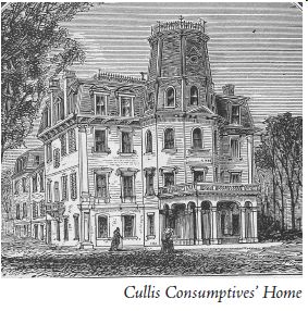
In 1871, Dr. Charles Cullis remodeled the facilities, converting the estate into the Cullis Consumptives’ Home. When it was founded in 1864 on Vernon Street, this was only the third free hospital in America for the treatment of consumption (tuberculosis).19 At Grove Hall it was able to care for 80 male and female patients in the last stages of pulmonary tuberculosis.20 This was a faith-based organization with a sign over the door, “Faith in God.” “The earnest and kind workers rely upon no endowment, but believe their aid comes in answer to prayer; and upon that they depend for daily expenses.”21 In 1897 a new, attractive building was erected facing Franklin Park opposite Seaver Street. The abandoned old building was considered an eyesore. Therefore, when neighborhood boys set fire to the historic structure in July 1898, the fire department let it burn. Near the new Consumptive Home, also under the same management, were two other homes: the Spinal Home and a Children’s Home for children of patients at the Consumptives’ Home. The facility always served those without funds and family to take care of them. It was still in operation in the early 20th century.
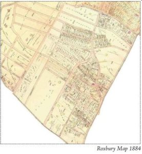
 Because large landowners like the Wilder family, the Cullis Consumptives’ Home, the Wales family, Charles Cotting, William McKechnie, Warner Spencer, and the Adams family held on to large tracts of land on both sides of Washington Street at Grove Hall, much of the land south of Quincy Street was still undeveloped even by 1894.22 With better public transportation and the annexation of Roxbury (1868) and Dorchester (1870) to Boston, some new residential development began, but the economic depression of 1873 slowed new building construction for about a decade. Wabon, Wyoming and Howland Streets near Warren Street were built up by 1884, but much of the land toward Elm Hill was still undeveloped. From Waumbeck St. to what is now Ruthven St. between Elm Hill Avenue and almost to Humboldt Avenue, land had been subdivided, but only four houses had been built by 1884.23 However, from 1885 to 1895 there was a building boom, especially west of Blue Hill Avenue. In 1886 Franklin Park was established south of Seaver Street. Also, Oakland Garden, an outdoor summer amusement park, was operating during this period. This so called “Summer Garden” was located between Erie Street and Columbia Road. It offered nightly theatrical presentations, regular band concerts, occasional outdoor sports, and an opportunity to see animals in a caged zoo. The Roxbury Highlands neighborhood of the 1870s and following decade was mostly middle and upper middle class Yankee Protestants or Irish. “Although the highlands was dominated by native [born] American Protestants in 1880, 38.9 percent of the population of this area were foreign-born and their children; by 1905 the proportion had risen to 57.5 percent.”24 On the Dorchester side, housing was developed earlier close to the Mount Bowdoin (Erie at Washington Street) and Harvard Street stations of the New York and New England Railroad. Other housing development was spurred on by the expansion first of the horse drawn street railways (Metropolitan and Highland Companies), and after 1889 by the electric street railways. The
 West End Railway Company located one of its large streetcar barns right at the northeast corner or Blue Hill Avenue and Washington Street. Until the coming of the street railways and their five-cent fares into town, it was simply impractical for most people to live in the Grove Hall area and commute into Boston. The street railways often expanded to areas before they were developed and therefore stimulated development and an increase in property values.
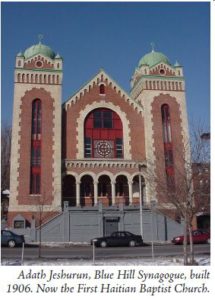
In 1894 the map of Dorchester shows no evidence yet of Jewish property owners along Blue Hill Avenue. However, by 1906 the maps reveal quite a number of Jewish property owners and a new and impressive synagogue on Blue Hill Avenue, called Adath Jeshurun.25 This huge and influential synagogue was built by a congregation of only 140 families in 1906.26 Some of the leaders of the synagogue were also in the real estate business. With the attraction of the new synagogue and the assistance of its leaders, the Jewish community nearby grew rapidly. Three other centers of Jewish settlement on Elm Hill, Erie Street/Mount Bowdoin, and Woodrow Avenue (Mattapan) grew rapidly in the coming years until they all merged into one large Jewish community. The early upwardly mobile, middle class Jewish residents were soon joined by thousands of lower income Eastern European Jews from the West End and Chelsea, where the 1908 fire had left many people homeless. For example, the Russian grandparents of the famous author and journalist, Theodore H. White, bought a wooden-frame house on Erie Street in 1912 for $2,000.27 He was born there three years later. His extended family was representative of the Eastern European Jewish immigrants settling into the area. White describes the neighborhood at that time, “When I was a child, milk was delivered in winter by horse-drawn sleigh… and Erie Street was lit by gas; and a real lamplighter passed before our house each dusk. Storekeepers had transformed Erie Street from the quiet residential neighborhood my grandparents had sought as Jewish pioneers in the district into a semi-permanent bazaar…Herrings were stacked in barrels outside fish stores…All butcher shops were kosher, sawdust on the floor, chopping blocks scrubbed clean every day, unplucked chickens piled in flop heaps in the store window…Pedlars, leading their horse-and-wagons through Erie Street, would yodel and chant their wares.”28
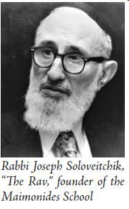
 In this same area about two blocks from the Mount Bowdoin train station, Beth El, the Fowler Street Synagogue was completed in 1912. By that time 300 Jewish families had settled in the Mount Bowdoin/Franklin Park district, and by 1920 the number had grown to 1,300 families (6,000 people).29 The congregation itself had grown to 400 members, with a women’s club, a men’s club, a free loan society, adult study groups, a Young Israel group, and a large religious school.30 In 1915 the Crawford Street Synagogue was built in the Elm Hill district and by 1923, under the leadership of Rabbi Louis M. Epstein, had grown to 1,300 members.31 Also in the Elm Hill district, the Jewish community was building what would become a great central synagogue-center for New England. The $750,000 Temple Mishkan Tefila was dedicated on September 13, 1925 and became the dominant Conservative Jewish institution in the area.32 That same year the Young Men’s Hebrew Association (YMHA) building opened a block away to provide gymnasium and meeting facilities for young men of the area. To meet the needs of the rapidly growing Jewish population, many substantial apartment blocks were built during these years. Notable leaders included Rabbi Mordecai Savitsky, an authority on Jewish law and kosher inspections, who was “reputed to possess the greatest memory of any living Rabbi.”33 In 1932 Rabbi Joseph Soloveitchik, who was regarded as the leader of modern Jewish orthodoxy, came to live on Ruthven Street. He and his wife Tonya founded the Maimonides School in 1937. Their educational goal was to produce young men and women who “integrated the secular knowledge that fits them for the American scene and the religious and spiritual wealth of their own tradition.”34
In October 1926 St. Mark’s Congregational Church became the first African American church to move to upper Roxbury, purchasing the 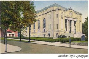 former Quaker Meeting House at Townsend Street and Humboldt Ave. Under Rev. Samuel Leroy Laviscount’s leadership, the church experienced considerable growth even though the neighborhood was not
predominantly black. The church soon founded the St. Mark’s Social Center that for many years played animportant role in service to the community, especially with programs for children and youth. Charles Street AME Church became the second African American church to move to Upper Roxbury when it bought the St. Ansgarius Swedish Episcopal Church building in 1939. The African American community grew around these two churches, especially around Humboldt Avenue and northwest of St. Marks.35
Theodore White and Nat Hentoff reveal in their tales of growing up in the area that there was a long-standing hostility between the Irish youth of nearby areas and the Jewish youth in the neighborhood.36 In the second half of 1943 violent attacks on Jewish youth increased from two or three reported incidents per month to eight in July, 11 in September, and many incidents in October.37 Wallace Stegner commented in the Atlantic Monthly, “Sometimes, fairly clearly, the violence was the ‘kid stuff’ that the Boston mayor and the police commissioner called it, and sometimes it was semi-organized warfare between neighborhood gangs. But very often it was a planned assault, preceded by the question, ‘Are you a Jew?”38 After the anti-Semitic violence in the fall of 1943, Protestant clergy organized an inter-faith committee in the area for the purpose of promoting good will between all religious and racial groups and equal police protection for all groups.
 In 1950 there were about 70,000 Jews in Roxbury, Dorchester and Mattapan. This was still the largest Jewish community in New England even though some families had moved to Brookline and Newton over the two previous decades. During the next seventeen years, almost every Jewish institution in Roxbury and Dorchester either closed or moved. The initial post-war exodus to the suburbs of synagogue members and a significant proportion of key leaders led the Jewish schools and synagogues to consider moving. For example, “by the early 1950s half of the approximately 800 families [of Mishkan Tefila] lived in the suburbs and commuted back to Roxbury for religious services and Hebrew school.”39 Also 28 out of 30 executive committee members lived in the suburbs or downtown.40 As key institutions such as the Hebrew Teachers College and four schools, along with several synagogues moved or closed in the 1950s, this triggered an even larger movement to the suburbs. In 1958, the move of Mishkan Tefila, which had been one of New England’s leading synagogues, to Newton, was especially significant.
Gerald Gamm argues in his book, Urban Exodus, that racial change took place more rapidly in Jewish neighborhoods like Grove Hall than in Catholic neighborhoods because the synagogues were not deeply rooted in a geographic area like Catholic parishes, the members were not required to live within the local neighborhood, and the synagogue congregations could make autonomous decisions to change or leave.42 These factors probably predisposed Jewish residents to move when faced with some other issues like real-estate agents encouraging panic selling and blockbusting, discriminatory lending and insurance practices, increased crime and arson, and racial change in adjacent areas.43 Blacks and other urban residents for many years faced discriminatory policies of the FHA and financial institutions which “redlined” some urban areas, refusing to give mortgage and home improvement loans. In the summer of 1968, the Boston Banks Urban Renewal Group (BBURG) was established to make available home mortgage funds to low-income black families within a designated area including Roxbury, South End, parts of Dorchester and Jamaica Plain, and the northern part of Mattapan. The BBURG program had some negative unintended consequences such as reckless speculation, a more rapid and tense process of racial change, and a later increase in foreclosures. However, as Gamm argues, it was not the primary cause of most of the Jewish exodus from the city.44 By 1970 that exodus was almost complete, even though some community members like Otto and Muriel Snowden had hoped for and worked to promote an integrated neighborhood.
One important community organization that has a long history of working to improve the neighborhood is Freedom House, founded in 1949 by Otto and Muriel Snowden. Otto had been directing the St. Mark Social Center, and Muriel was a graduate of Radcliffe and the New York School of Social Work. In 1952 they were able to raise funds to buy the Hebrew Teachers College building on Crawford Street. They set out with the mission “to conserve and improve the Upper Roxbury neighborhood and to provide opportunities for greater interracial contact and understanding both within the community itself and between its residents and those of Greater Boston.” The Snowdens planned programs and events to bring together Jewish and Black youth. They sought to promote an integrated community living in peace and understanding. In those years their “efforts included the establishment of block organizations to deal with neighborhood services including public safety, recreation, trash removal, and street cleaning.”45 As most of the Jewish residents moved out of Roxbury, Freedom House began to work more on the Washington Park Urban Renewal project. In the 1960s, Freedom House’s Work and Study Project sought to improve the neighborhood by involving high school and college youth in painting houses and tutoring school children. Over the years Freedom House worked on many issues such as affirmative action, innovative educational programs, school integration, urban renewal, and sponsored many programs to provide opportunities for urban youth. The organization became a nationally renowned civic center, and Muriel Snowden received a MacArthur Foundation Grant in 1988.
The most explosive events in Grove Hall’s history were the 1967 riots that took place on Friday, Saturday and Sunday, June 2-4. About a year before this, Doris Bland had organized a group called the Mothers for Adequate Welfare (M.A.W.), and they had held several marches during the year to seek improvements in the welfare system. On Thursday afternoon, June 1, about 30 M.A.W. members started a silent vigil in the Grove Hall welfare office at 515 Blue Hill Ave. A small group of protesters also marched outside, and the vigil became an overnight sit-in. The mothers were upset with their welfare checks being cut off without warning; and hostile treatment by social workers, supervisors, and police in the Blue Hill welfare office, in addition to several other grievances.46
On Friday afternoon about 50 men and women, including some children were still holding the sit-in when the welfare workers attempted to close the office for the weekend. The protesters chained the doors shut and requested to speak to the city Welfare Director, Daniel J. Cronin. When he came, they asked to speak with him in the presence of the crowd outside rather than let him come in. About this time a welfare worker inside was reported to have had a heart attack. Police then sought to assist the worker and get the other welfare workers out, but bystanders attempted to block their entry. The police eventually made their entry through a window and cutting the chains. A woman inside yelled that the police were beating people, a door window smashed, and things became chaotic as police tried to remove the workers and the women involved in the sit-in. Black leaders believed the excessive force used by police started and furthered the riot.47 A large crowd had gathered, and several times it surged across the street at the line of police. Rocks, bottles, and bricks flew through the air, battering civilian and police cars, and injuring people. Cars were overturned. The crowd grew to 1,000, and an equal number of police were called in. The police fired 60 rounds over the heads of the rioters. Through the night many store windows were broken and the stores looted and set on fire up and down Blue Hill Avenue. This resulted in 15 blocks of debris-scattered sidewalks and streets, with 45 persons injured and 44 arrested, including Civil Rights leader, Thomas Atkins and Byron Rushing. There were accusations of police brutality during and after the arrests.48
On Saturday night, June 3, the violence continued with a fireman being shot in the wrist, and dozens of gangs of roving youth engaging in spontaneous violence. They went around smashing windows, looting stores, and sounding false alarms, while police tried to control the area. Even with the presence of 1,900 policemen, rioting continued on Sunday night. Although there was still tension in the air, the situation had quieted down by Monday evening. Over the three nights of rioting 75 people were injured and 60-70 were arrested.49 In addition to the millions of dollars of property damage, the rioting had an impact on the social and business life of Blue Hill Avenue that lasted for many years. Twenty years later in 1987, a new 28,000 square foot welfare office was opened nearby on Washington Street offering assistance with employment and training, housing, and health care enrollment.
The following April there were more riots in the Grove Hall area (and other neighborhoods) after the assassination of Martin Luther King, Jr. Some looting and arson took place, as well as stoning of cars and buses. A group of black volunteers with white armbands went around the community seeking to cool things down. On Friday, April 5, a group of 400 protesters went to the Jeremiah Burke High School and vandalized some furniture and displays. One teacher was injured and a couple of others were pulled from their cars. With the help of black leaders, things were quiet by Saturday morning. Although 30 were arrested and 13 injured, these riots were far less extensive than in other cities at the time.50
In 1977 Mayor Kevin White set forth an ambitious plan to revitalize Blue Hill Avenue and Grove Hall, but four years later very little had been accomplished.51 This seemed to be typical of the 25 years following the Blue Hill Avenue riots. Various politicians promised plans to revive the Grove Hall community, but actual progress was quite limited. In April 1983 Governor Dukakis spoke to 400 people in Grove Hall about economic development in the neighborhood comparable to Lowell’s revival, cautioning that it would not happen overnight.52 Indeed, it would not happen any time soon. In the 1987 Boston Globe article, “A Street Forgotten,” Mike Barnicle commented, “In the short stretch between Grove Hall and Dudley Street, Blue Hill Avenue gives every outward appearance of being ready for the grave... In this one-and-a-half mile strip of asphalt, there are 58 boarded-up apartment houses and storefronts. There are 24 vacant lots, some of them as big as prairies.”53 According to a 1987 city report, in the general area between Warren Street and Blue Hill Avenue, there were 360 empty lots and 117 vacant buildings (nine percent).54 In the 1980s the new state welfare office opened, a Burger King restaurant started up, and the Franklin Park Zoo reopened, but overall trends in the community were not positive. This was a time of increased drug-related crime, shootings, murders, and gang activity. This caused an increased level of fear and slowed redevelopment of the business district.
In 1988 Mayor Ray Flynn tried to reassure community leaders that the city was committed to redeveloping their neighborhood. Later that year the city’s Public Facilities Department and community leaders initiated a $7.8 million effort “to attract new businesses, create jobs, develop housing, and improve the infrastructure.”55 This involved the city selling five vacant buildings and making money available from Community Development Action Grants to develop other privately owned properties. Neighborhood leaders considered this a step in the right direction, but not a comprehensive enough plan.
In 1993 Mayor Menino promised to work for the revitalization of Blue Hill Avenue. The leadership of the Blue Hill Avenue Initiative Task Force, the coordination of various government resources, and the involvement of various other community groups like the Dudley Street Neighborhood Initiative over the last fifteen years have resulted in many positive and substantial improvements. Between 1993 and 2003, the area received approximately $90 million in public and private investment in housing, business, and infrastructure development. In that period, the investment “produced more than 200 units of affordable housing, created or improved more than 30 businesses, and created or retained more than 550 jobs.”56
During this period one central building block in this effort has been the $13 million Mecca Mall in the heart of Grove Hall that opened in 2000-2001. The Neighborhood Development Corporation of Grove Hall was a key organization in developing the property. The Mall provided the retail anchor for the business district and also created many job opportunities. This has also encouraged additional business and housing development in the years since it opened. In 2007 the historic Silva Building (formerly called Regents Hall) was restored and reopened at the corner of Warren Street and Blue Hill Avenue, providing space for several businesses including OneUnited Bank and the Long Bay Management real estate firm (the owner and developer).58 Also in the area, Charles Street AME Church is redeveloping the former Skycap Plaza building into the Roxbury Renaissance Center, Habitat for Humanity is building 24 residential units adjacent to Blue Hill Avenue, and Nuestra Communidad Development Corporation is building 48 affordable apartments near the area at the former Kasanof Bakery site.59 These are just a few of the many recent redevelopment efforts in the community. In recent years Project RIGHT60 has provided a collaborative approach to improving other aspects of the community by supporting neighborhood associations, coordinating electoral advocacy efforts, and guiding community development.
Over its history, Grove Hall slowly changed from an untamed wilderness to a thriving business and residential district, and back to a new wilderness of sorts, and once again has slowly changed back to a thriving business and residential district. In conclusion we should all remember the words of hope written by a young student at the Lewis Junior High School. In a 1965 prize-winning essay on “Urban Renewal in Roxbury,” eighth grader Brenda Bugg wrote, “Roxbury will be beautiful again because people cared. I hope people will always care.”61
1. William Richard Cutter and William F. Adams, Genealogical and Personal Memoirs Relating to the Families of the State of Massachusetts (New York: Lewis Historical Publishing Co., 1910), 1344. See also –“Descendants of Edward Payson,” Rootsweb, http://freepages.genealogy.rootsweb.ancestry.com/~batemanp/pilgrims/test... (accessed 19 May 2009).
2. John William Linzee, The History of Peter Parker and Sarah Ruggles of Roxbury, Mass. (Boston: S. Usher, 1913), 362-3. Will mentions sons –(John, Ephraim, and Samuel) and sons-in-law (Benjamin Tucker and the Capens).
3. Ibid.
4. David M. Balfour, “The Taverns of Boston in Ye Olden Time,” The Bay State Monthly 2 (1885):116.
5. L. Vernon Briggs, Genealogies of the Different Families Bearing the Name Kent in the U.S. (Boston: Rockwell and Churchill Press, 1898), 37-38. See also Mellen Chamberlin, A Documentary History of Chelsea (Boston: Massachusetts Historical Society, 1908), 1:374.
6. Francis Samuel Drake, The Town of Roxbury (Boston: Municipal Print Office, 1908), 223.
7. Edward W. Gordon, Boston Landmarks Survey of Dorchester: Grove Hall, 1995, www.dorchesteratheneum.org/page.php?id=622 (accessed 18 May 2009).
8. L. H. Bailey, The Standard Cyclopedia of Horticulture. 2nd ed. 6 vols. (New York: Macmillan Co., 1917), 3:1603.
9. Ibid.
10. Drake, 199.
11. Ibid., 199-200.
12. Frederick James Wood, The Turnpikes of New England (Boston: Marshall Jones Co., 1919), 146.
13. Ibid., 146-148.
14. D.A.R. Roxbury Chapter, Glimpses of Early Roxbury (Boston: Merrymount Press, 1905), 30.
15. Henry A. Sprague, A Brief History of the Massachusetts Charitable Fire Society (Boston: Little, Brown, and Company, 1893), 35. (T.K. Jones was a trustee, vice president and president of this organization).
16. Walter Eliot Thwing, History of the First Church of Roxbury, Mass. (Boston: W.A. Butterfield, 1908).
17. Abel Bowen, Bowen’s Picture of Boston or the Citizen’s and Stranger’s Guide to the Metropolis of Massachusetts, 3rd ed. (Boston: Otis, Broaders, and Company, 1838), 246.
18. Anthony Mitchell Sammarco, Roxbury. Images of America Series (Charleston, S.C.: Arcadia Pub., 1997), 68. See also the “American Orthopedic Institute,” Boston Medical and Surgical Journal 38 (1848):363.
19. S. Adolphus Knopf, A History of the National Tuberculosis Association (New York: National Tuberculosis Association, 1922), 9.
20. Sammarco, Roxbury, 69.
21. Edward B. Lane, “Some Roxbury Institutions,” The Roxbury Magazine, 1899, 27.
22. Boston Atlas, “1894 Dorchester Combine Final Map,” www.mapjunction.com.
23. Boston Atlas, “1884 Roxbury Combine Final Map,” www.mapjunction.com.
24. Sam Bass Warner, Jr., Streetcar Suburbs: The Process of Growth in Boston, 1870-1890, 2nd edition (Cambridge, Mass.: Harvard University Press, 1978), 110.
25. Boston Atlas, “1906 Roxbury Combine Map,” and “1904 Dorchester Combine Map,” www.mapjunction.com.
26. Jonathan D. Sarna and Ellen Smith, eds., The Jews of Boston (Boston: The Combined Jewish Philanthropies of Greater Boston, 1995), 144.
27. Theodore H. White, In Search of History: A Personal Adventure (New York: Harper and Row, Publishers, 1978), 14.
28. Ibid., 16, 26, 27.
29. Gerald Gamm, Urban Exodus: Why the Jews Left Boston and the Catholics Stayed (Cambridge, Mass.: Harvard University Press, 1999), 69-70.
30. Ibid.
31. David Kaufman, “Temples in the American Athens: A History of the Synagogues of Boston,” in The Jews of Boston, ed. by Jonathan D. Sarna and Ellen Smith (Boston: Combined Jewish Philanthropies of Greater Boston, 1995), 191.
32. Ibid., 193. (This is the building now owned by the United House of Prayer for All People.)
33. Hillel Levine and Lawrence Harmon, The Death of an American Jewish Community: A Tragedy of Good Intentions, pb. edition (New York: The Free Press, 1993), 34.
34. Ibid., 40.
35. Gamm, 61-64. See Map 11 and Map 12.
36. White, 25. Nat Hentoff, Boston Boy: Growing Up With Jazz and Other Rebellious Passions (Philadelphia: Paul Dry books, 2001), 18,19.
37. Wallace Stegner, “Who Persecutes Boston,” Atlantic Monthly, July 1944, 45.
38. Ibid.
39. Hillel Levine and Lawrence Harmon, 59.
40. Ibid.
42. Ibid., 18,19.
43. Ibid., 37-42.
44. Ibid., 50.
45. Hillel Levine and Lawrence Harmon, 57.
46. “Women Stage Overnight Sit-in, Rap Roxbury Welfare Handling,” Boston Globe, 2 June 1967, Evening ed., 24.
47. Jack Tager, Boston Riots: Three Centuries of Social Violence (Boston: Northeastern Univ. Press, 2001), 182.
48. “Sit-In Escalates to Riot,” (and other articles), Boston Globe, 3 June 1967, 1, 4 (regular and evening editions).
49. Boston Globe, 4, 5, and 6 June 1967, 1.
50. Tager, 185.
51. Kenneth J. Cooper, “Blue Hill Avenue: A Dream Gathers Dust: 4 Years Later, Business, Transit Plans Haven’t Happened,” Boston Globe, 22 October 1981, 1.
52. Joanne Ball, “City Revival a Long Road, Dukakis Tells Grove Hall,” Boston Globe, 12 April 1983, 1
53. Mike Barnicle, “A Street Forgotten,” Boston Globe, 1 April 1987, 17.
54. The Boston Plan: Revitalization of a Distressed Area: Blue Hill Avenue (Boston: City of Boston, 1987), I-9.
55. Desiree French, “Revitalization Gets Serious at Grove Hall: A $7.8 million Program Formed to Aid Roxbury Business District,” Boston Globe, 26 March 1988, 41.
56. Mayor Menino Leads Tour of Blue Hill Avenue,” City of Boston Press Releases, 26 March 2003, www.cityofboston.gov/news/default.aspx?ID=1637 (accessed 1 June 2009).
57. “Blue Hill Avenue: Progress, 1993-2003,” City of Boston, Dept. of Neighborhood Development, www.cityofboston.gov/dnd/pdfs/BHA_Map_3FLAT.pdf (accessed 15 June 2009).
58. Ron DePasquale, “Grove Hall’s Renaissance; New Development Caps Hub Area’s Revival as a Commercial Mecca.” Boston Globe, 10 Feb. 2007, E23.
59. Roxbury Renaissance Center, http://csrrc.org ; Habitat for Humanity, Greater Boston, Blue Hill Place, www.habitatBoston.org/projects.html#bhp ; Nuestra’s Kasanof Bakery Development, www.nuestracdc.org/kasanof.html (accessed 3 June 2009).
60. Project RIGHT stands for Rebuild and Improve Grove Hall Together
61. Brenda Bugg, “Urban Renewal in Roxbury,” Freedom House, Essay contest winner, Lewis Jr. High School, 23 April 1965, www.lib.neu.edu/archives/freedom_house/Essaytyped.htm (accessed 1 June 2009).